Show Mobile Navigation
Powered by Blogger.
America
Showing posts with label America. Show all posts

Tuesday, 14 October 2014

Wall of Tears, Mount Waialeale, Hawaii

WTH - Tuesday, October 14, 2014
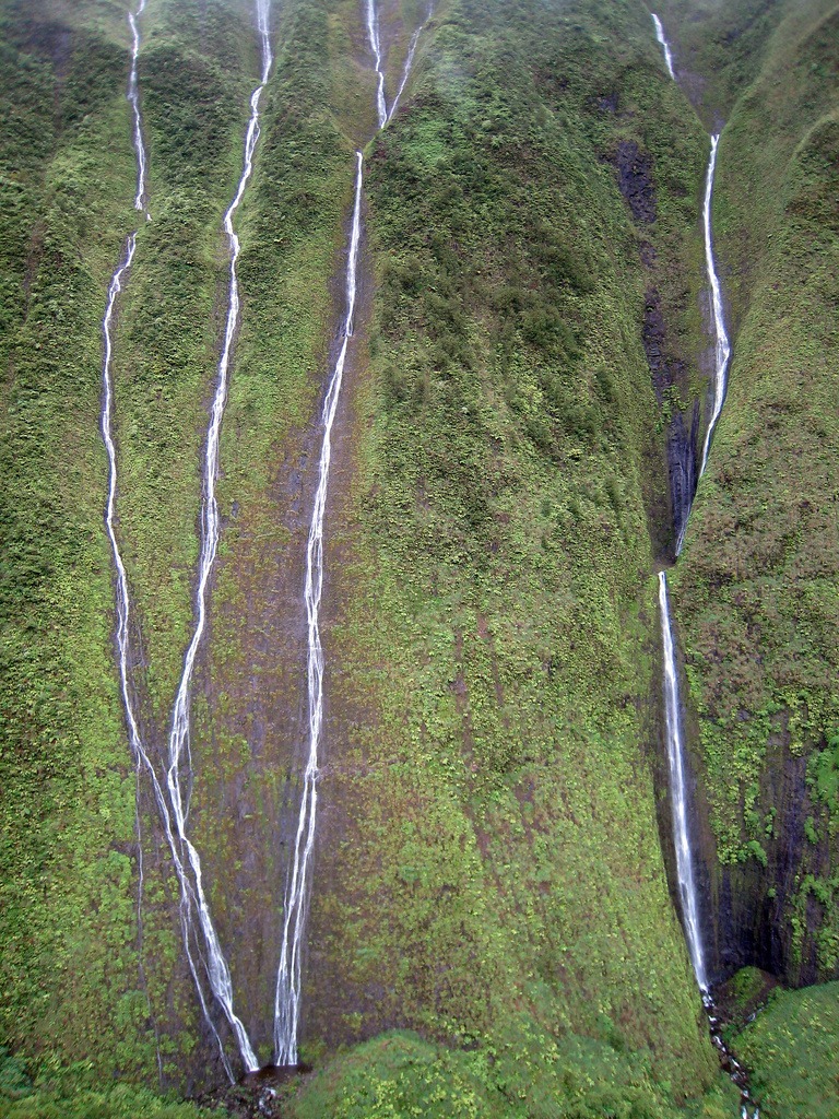
Mount Waialeale (or Wai'ale'ale) is a volcanic crater and the second highest point on the island of Kauai in the Hawaiian Islands. In the Hawaiian language, Wai'ale'ale means “rippling water” or “overflowing water.” Averaging more than 452 inches (11,500 mm) of rain a year since 1912, with a record 683 inches (17,300 mm) in 1982, its summit is one of the wettest spots on earth. As this rainwater makes its way down the 5,148-feet tall peak, they form innumerable streams. One spot on Mt. Waialeale is called the “Wall of Tears” because there are so many waterfalls plummeting down the deep, tropical green sides of the mountain that it looks as if it is crying.

Mount Waialeale isn’t easily accessible on foot. The sides are near vertical and ground is covered with trees and plants with a thick undergrowth of ferns. There are a few hiking trails in the area. The only way to really see the Wall of Tears is by helicopter, and even then you have to get lucky since the area is usually shrouded with clouds.

mt-waialeale-6

There are several reasons why Wai'ale'ale receives so much rain. First, Kauai is the northernmost of the main Hawaiian Islands, so it has more exposure to frontal systems that bring rain in the winter. Second, Wai'ale'ale has a round and conical shape, which exposes all sides of its summit to moisture-laden winds. Third, its summit lies just below the trade wind inversion layer of 6,000 feet (1,829 m), above which trade-wind-generated clouds cannot rise. And finally, the mountain's steep cliffs cause the humid air to rise quickly over 3,000 feet (910 m) in less than a half mile (800 m) and drop a large portion of its rain on one spot.

The summit itself is rather barren, despite all the water it receives. One of the reasons for that is that few plants and trees can handle that much rain. Also, since the summit is shrouded in clouds on most days of the year, little sunshine reaches the ground to foster plant growth. However, fungi and lichen flourish here.

mt-waialeale-5
mt-waialeale-1
mt-waialeale-2
mt-waialeale-3
mt-waialeale-7
mt-waialeale-8
mt-waialeale-9

Sources: WikipediaTo-Hawaii

Berkeley Pit, the Pit of Poison

WTH - Tuesday, October 14, 2014
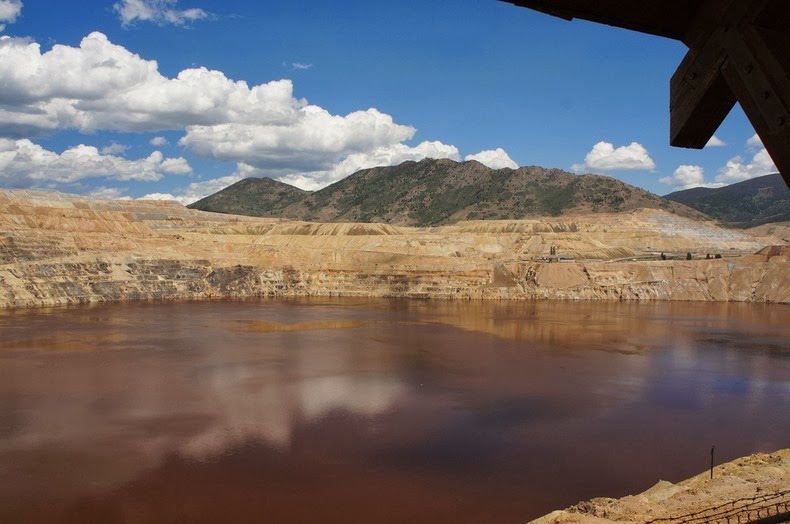
The Berkeley Pit is an abandoned open pit copper mine located in Butte, Montana, United States. It is over a mile long, half a mile wide, and over a third of a mile deep. During its heydays, Berkeley Pit supplied a sixth of the world's copper needs, and during the 27 years of operation approximately 320 million tons of the ore were extracted enough to “pave a four-lane highway four inches thick from Butte to Salt Lake City and 30 miles beyond,” according to Pitwatch.org. The once thriving copper mines of Butte earned the district the title of “the richest hill in the world.”

Today, the pit is filled with nearly 30 billion gallons of highly acidic water laced with toxic chemicals like arsenic, cadmium, zinc, and sulfuric acid that threaten the environment and the water supply of the nearby town of Butte.

berkeley-pit-1

Rich copper deposits were known at Butte since the early 1870’s, although development was delayed due to lack of adequate transportation required to bring the ore to smelters. Without the necessary rail lines and recovery facilities, Butte’s copper ore was sent to Swansea, Wales for processing. By the late 1880s, new railway lines were laid connecting Butte with the Union Pacific out of Ogden, Utah. By the time electricity was discovered, Butte had all the infrastructural components needed to meet the burgeoning demand for copper needed to electrify cities.

From 1892 until 1903, the Anaconda Mine was the largest copper-producing mine in the world accounting for 20% of all US copper production. For nearly 70 years, mining for copper was done by dropping shafts into the earth or boring tunnels through the hills. As price of copper soared, Butte needed more efficient mining techniques, and in 1955, the area introduced open-pit mining in the form of Berkeley Pit.

Within the first year of operation, the Berkeley Pit extracted 17,000 tons of ore per day at a grade of 0.75% copper. Ultimately, about 1 billion tons of material was mined from the Berkeley Pit, of which copper constituted nearly a third. Other metals including silver and gold were also extracted. But steep, continuous declines in copper prices after the Vietnam war led to the eventual shut down of Berkeley operations in 1982.

During mining in Butte, pumps were used to remove surface runoff and groundwater from the mines. When the mine and the pumps were shutdown, the Berkeley Pit began to fill with water rising at about the rate of one foot a month. Today the pit is filled to a depth of about 900 feet or 270 meters.

The pit and its water present a serious environmental problem because the water, with dissolved oxygen, allows pyrite and sulfide minerals in the ore and wall rocks to decay, releasing acid. When the pit water level eventually reaches the natural water table, estimated to occur by around 2020, the pit water will reverse flow back into surrounding groundwater, polluting into Silver Bow Creek which is the headwaters of Clark Fork River. An example of a disaster to come happened in 1955 when a flock of migrating snow geese landed in the Berkeley Pit, killing at least 342 of them.

But in the same year the birds died, a chemist studying the water composition of the pit discovered a robust single-celled algae known as Euglena mutabilis thriving in the toxic waste of the Berkeley Pit. Over the next few years, over 40 different species of organisms were discovered in the pit. Intense competition for the limited resources caused these species to evolve the production of highly toxic compounds to improve survivability – some of the compounds isolated from these organisms have shown to fight against cancer cells.

Berkeley Pit is currently just another tourist attraction. There's a small museum, gift shop and a viewing platform located above the water.

berkeley-pit-6
berkeley-pit-8
berkeley-pit-7
berkeley-pit-9
berkeley-pit-3
berkeley-pit-4
berkeley-pit-5

Monday, 13 October 2014

Seven Mile Bridge in Florida

MY GID - Monday, October 13, 2014
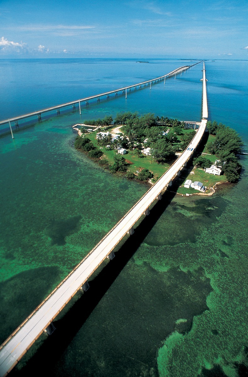
The Seven Mile Bridge is an iconic bridge in the Florida Keys of United States, stretching out into the open sea, connecting Knight's Key in the Middle Keys to Little Duck Key in the Lower Keys. At the time of its completion in 1982, it was the longest continuous concrete segmental bridge in the world, and is currently one of the longest bridges in America.

Seven Mile Bridge actually consist of two bridges in the same location. The older bridge, originally known as the Knights Key-Pigeon Key-Moser Channel-Pacet Channel Bridge, was constructed from 1909-1912 as part of the Overseas Railroad. After the railroad sustained considerable damage during the Labor Day Hurricane of 1935, the bridge was refurbished for automobile use only. Dismantled tracks was recycled, painted white, and used as guardrails. It had a swing span that opened to allow passage of boat traffic, near where the bridge crosses Pigeon Key - a small island that once served as the work camp for the Florida East Coast Railway. When Hurricane Donna in 1960 inflicted further damage, decision to construct a new bridge was made.

sevenmile-bridge-florida-5

A new, wider and sturdier Seven Mile Bridge was built right next to it from 1978 to 1982. When that happened, the original Seven Mile Bridge was nudged out of Florida’s transportation system. The vast majority of the original bridge still exists, used as fishing piers and access to Pigeon Key, but the swing span over the Moser Channel of the Intracoastal Waterway has been removed.

The total length of the new bridge is just under seven miles at 6.79 miles (10.93 km), and is shorter than the original. Each April the bridge is closed for approximately 2.5 hours on a Saturday and a "fun run," known as the Seven Mile Bridge Run, of 1,500 runners is held commemorating the Florida Keys bridge rebuilding project. The event began in 1982 to commemorate the completion of a federally funded bridge building program that replaced spans that oil tycoon Henry Flagler constructed in the early 1900s to serve as a foundation for his Overseas Railroad.

The old bridge is still a popular spot with both locals and tourists, but it’s slowly falling apart. Salt water and storms are eroding the bridge faster than the state can afford to repair it. Much of the bridge is now closed – only a 2.2 mile section of the Old Seven Bridge is still open to pedestrians and cyclists.
Two years ago, a nonprofit community group called “Friends of Old Seven” was formed to try to preserve, and if possible, repair the bridge. The Florida Department of Transportation, which owns the bridge, cannot afford to sink a lot of money into the bridge’s upkeep, but is still willing to donate half of the $18 to $20 million required to repair the bridge. The community is now working hard to put up the other half.

sevenmile-bridge-florida-11
sevenmile-bridge-florida-2
sevenmile-bridge-florida-13
sevenmile-bridge-florida-14
sevenmile-bridge-florida-1
sevenmile-bridge-florida-4
sevenmile-bridge-florida-6
sevenmile-bridge-florida-12
sevenmile-bridge-florida-8
sevenmile-bridge-florida-9
sevenmile-bridge-florida-10

Sources: WikipediaWLRN
Previous
Editor's Choice